

A swarm of earthquakes rattled western Nevada early Friday, including a magnitude 5.2 centered southeast of Silver Springs, according to the U.S. Geological Survey. The shaking was felt across Fallon, Fernley, Yerington, and the Reno-Carson corridor as the region continues to experience heightened seismic activity following a magnitude 5.7 earthquake two weeks ago.
USGS data shows the 5.2 struck at a depth of about 12 kilometers shortly after 1 a.m., with multiple aftershocks ranging from magnitude 2.0 to 4.1 recorded in the hours that followed. The epicenter lies within the Walker Lane, a major tectonic corridor that runs along the eastern Sierra Nevada and across western Nevada, a region responsible for many of the earthquakes felt in Churchill and Lyon counties.
Friday’s activity is part of an ongoing sequence that began with the April 5.7, which was widely felt across northern Nevada and generated hundreds of aftershocks. Seismologists say the latest quakes are consistent with a typical aftershock pattern in the Walker Lane, where faults often rupture in clusters rather than single, isolated events.
According to USGS, this sequence is behaving as scientists expect after a magnitude 5 earthquake in the Walker Lane. Aftershocks in this region commonly continue for weeks or even months, and additional magnitude 4 or magnitude 5 earthquakes are possible as the crust continues to adjust.
The Walker Lane accommodates roughly 20 to 25 percent of the motion between the Pacific and North American plates, making western Nevada one of the most seismically active regions in the interior West. Unlike the San Andreas Fault, which is a single, well-defined boundary, the Walker Lane is a broad, branching network of faults that shift, slip, and interact with one another. This structure produces frequent earthquake swarms, migrating sequences, and long aftershock chains, the kind of activity Fallon residents have been feeling for the past two weeks.
Western Nevada has experienced similar multi-fault sequences in the past, including a series of major earthquakes in 1954 that produced several magnitude 6 and magnitude 7 events near Fallon, Fairview Peak, and Dixie Valley. Those quakes ruptured multiple faults in rapid succession, a pattern scientists say is characteristic of the Walker Lane, the same tectonic zone driving the current swarm.
Geologists say the region’s faults tend to release strain in bursts, which is why residents may feel several moderate earthquakes over a short period rather than one large event. The 5.7 and 5.2 are part of that same stress-release process.
Residents in Fallon reported rolling-wave shaking and several sharp jolts overnight. No significant damage has been reported, but emergency officials are monitoring the swarm as aftershocks continue.
USGS says additional earthquakes are likely in the coming days as the sequence evolves.
WHAT TO EXPECT NEXT
Aftershocks will continue. USGS says aftershocks following a magnitude-5 event in the Walker Lane can last weeks to months, with shaking that may come and go in clusters.
More moderate quakes are possible. It is normal for sequences in this region to produce additional magnitude-4 or magnitude-5 earthquakes as stress redistributes along nearby faults.
Shaking may migrate. Faults in the Walker Lane often interact, meaning activity can shift slightly north or south over time — even if the mainshock was centered near Silver Springs.
Most aftershocks will be small. The majority will fall in the M1–M3 range, though residents may feel the stronger ones, especially in Fallon, Fernley, and Silver Springs.
No signs of a larger imminent quake. USGS emphasizes that aftershocks are expected and do not indicate that a larger earthquake is building.
WHAT FALLON RESIDENTS CAN DO
Drop, Cover, and Hold On. If shaking starts, get low, protect your head and neck, and stay where you are until the shaking stops.
Secure heavy items. Bookshelves, TVs, mirrors, and tall furniture should be anchored. Many injuries in moderate quakes come from falling objects.
Know your safe spots: under a sturdy table, next to an interior wall, away from windows and heavy items.
Check your home after a strong shaking. Look for cracks, fallen items, and gas or water leaks. If you smell gas, leave immediately and contact your utility provider.
Prepare a basic kit. Include water, medications, flashlights, batteries, and copies of important documents. Even small quakes can disrupt utilities.
Report what you feel. USGS’s “Did You Feel It?” tool helps scientists map shaking intensity and improve future hazard assessments.
Sidebar 3
TIMELINE: RECENT EARTHQUAKE ACTIVITY IN WESTERN NEVADA
April 5 — Magnitude 5.7: A strong earthquake strikes western Nevada, widely felt across Fallon, Fernley, Silver Springs, Yerington, and the Reno–Carson area. Hundreds of aftershocks follow in the first 48 hours.
April 6–12 — Aftershock sequence continues. Dozens of magnitude 2 to 4 earthquakes are recorded as the Walker Lane adjusts following the 5.7 mainshock. Residents report rolling-wave shaking on multiple days.
April 13–20 — Swarm activity increases. Clusters of small quakes occur southeast of Silver Springs and north of Fallon. USGS notes the pattern is consistent with stress transfer along nearby faults.
April 21–28 — Migrating activity. Shaking shifts slightly north and east, with several magnitude-3 and magnitude-4 earthquakes felt in Fallon and Fernley. Scientists say this migration is typical of Walker Lane sequences.
May 1, 1:00 a.m. — Magnitude 5.2: A strong earthquake hits southeast of Silver Springs, waking residents across Churchill and Lyon counties. Multiple aftershocks follow, including several in the magnitude-3 to magnitude-4 range.
May 1, morning — Aftershocks continue, with USGS recording dozens of smaller quakes as the sequence remains active. Emergency officials report no major damage but continue monitoring.
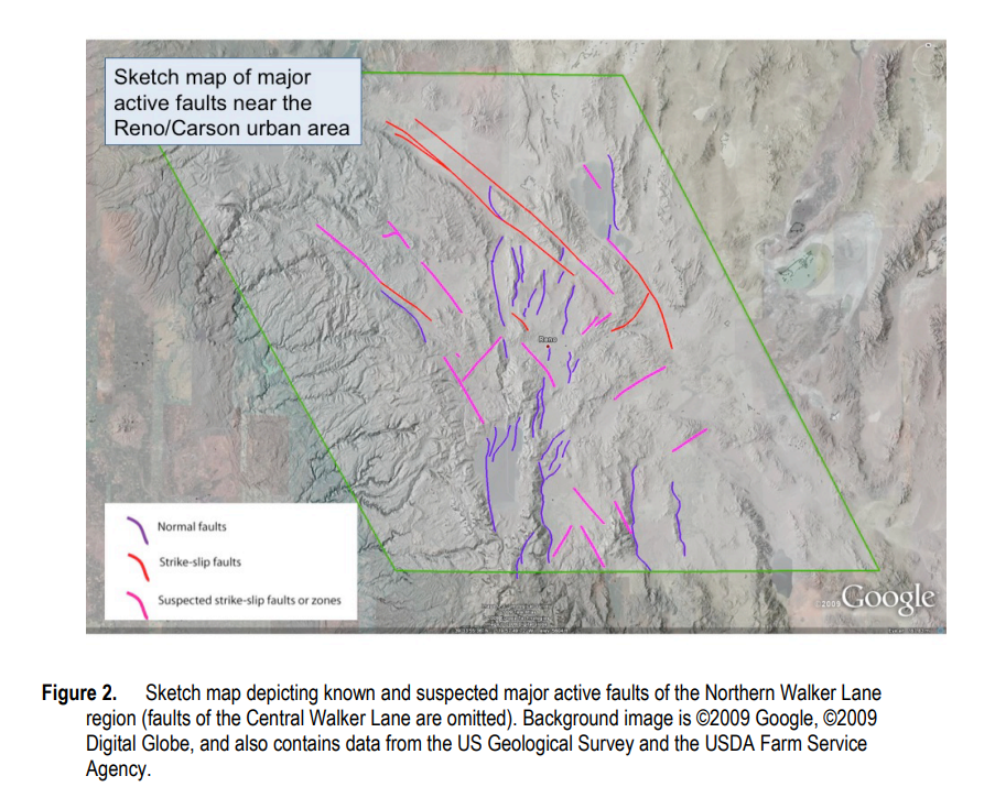
Map shows the Walker Lane, a major tectonic zone running along the eastern Sierra and across western Nevada. The region’s branching faults are responsible for frequent earthquake swarms affecting Fallon, Silver Springs, Fernley, and the Reno-Carson corridor. Map courtesy of the U.S. Geological Survey.


Comment
Comments