Reducing flood risks along the Carson River is the primary purpose of the updated Carson River Watershed Floodplain Management Plan (CRFMP). The plan was finalized last year and is now being presented to governing bodies in the Carson Watershed. The document lays out the characteristics of the watershed, flood history, risk assessment and suggested emergency responses.
Members of the Carson River Coalition Floodplain Management Working Group with representatives from Alpine, Calif., Carson City, Churchill, Douglas, Lyon, and Storey Counites served as the steering committee for the plan. Ed James, general manager of the Carson Water Subconservancy District (CWSD), presented the plan to Churchill County commissioners at their July 16 meeting where they voted to adopt the plan. Three previous plans were released in 2008, 2013, and 2018.
The plan provides a regional approach to floodplain management, seeks to protect floodplains from development, and offers suggestions to reduce flood damage on a watershed scale. This plan affirms the “Living River Approach,” which recognizes the importance of balancing the river’s natural floodplain form and function with various land uses.
“Once the floodplain, and especially the river’s meander belt corridor, is impacted by development, the river loses the ability to reestablish its natural functions,” stated Brenda Hunt, CWSD Watershed Program Manager. “Agricultural fields near the channel are critical for floodwater attenuation, groundwater recharge, nonpoint-source pollution buffering and providing habitat for wildlife.”
The Carson River Watershed is 3,966 square miles, with 606 square miles in California and the balance in Nevada. The Carson River flows 184 miles from its headwaters in Alpine County, Calif., to the terminus at the Carson Sink in Churchill County, north of Fallon. The updated plan also acknowledges the economic impact a flood can have on communities, noting the 2017 flood damage totaled $9.6 million to the six counties in the watershed.
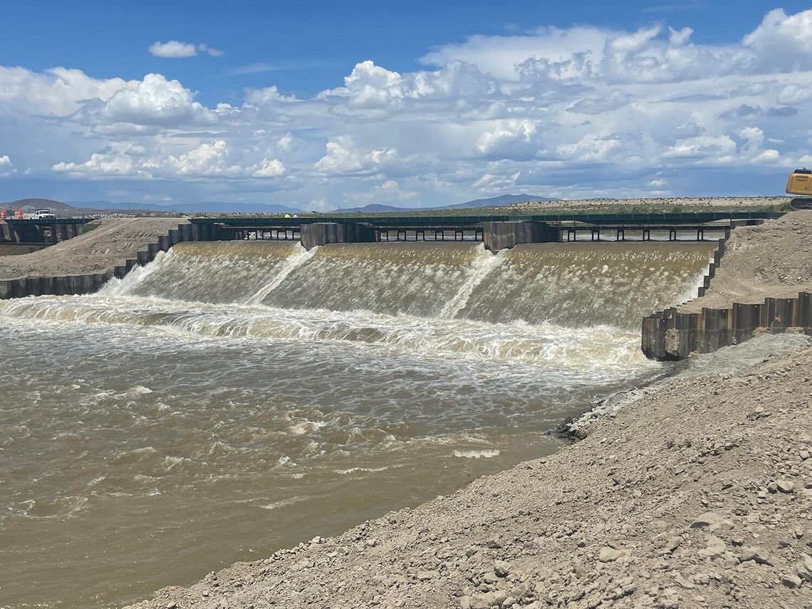
The plan states because there is no upstream storage, record snowfall in 2017 led to record runoff in the river and into Lahontan Reservoir. The reservoir was designed to store 300,000 acre-feet of water; the inflow in 2017 was three times this amount. James said Churchill County officials reacted swiftly in early 2017 when predictions of high-water flows along the river threatened Fallon. The CWSD had already studied the use of a weir to reduce flooding risks, and he was happy to see it come to fruition within six weeks.
The first weir was constructed on the V-Line Canal off Casey Road and sent water into the desert south of Fallon. He added the Nevada Department of Transportation also responded quickly to install culverts under Highway 95 South and at Highway 50 near Grimes Point to funnel the water into the “Big Dig,” a massive ditch running from Carson Lake north to the Stillwater wetlands.
Churchill County was threatened again in 2023 when another high-water year forced officials to construct a second, bigger weir. The Big Dig ditch was cleaned out to ensure water flowed unobstructed all the way to the Stillwater wetlands.
CWSD is a Cooperating Technical Partner with the Federal Emergency Management Agency (FEMA), and the district has received $6.9 million from FEMA from 2010 to 2024 for projects like flood-hazard mapping, mitigation planning and outreach.
The types of flooding along the Carson River include riverine flooding in the main channel, alluvial fan flooding from flash floods, stormwater flooding, and flood-after-fire debris flows and mud flows. Flood hazards primarily occur when developers build within the floodplain, river corridor or in and around alluvial fans. It was noted Carson City purchased all the riverine floodplain lands in Carson City to offset any potential property damage.
Funding was the number one barrier to mitigation listed by each county, the management plan states. Carson City is the only watershed county that has a stormwater utility that helps fund mitigation projects, and the idea of a tax or flood utility can be met with fierce resistance.
The plan concludes with a strategy to implement the floodplain management plan. It suggested each community adopt a Hazard Mitigation Plan to effectively handle emergencies and to become eligible for FEMA disaster assistance.
The 150-page plan can be found in its entirety on the CWSD website, cwsd.org.









Comment
Comments